
Proposed Land Use
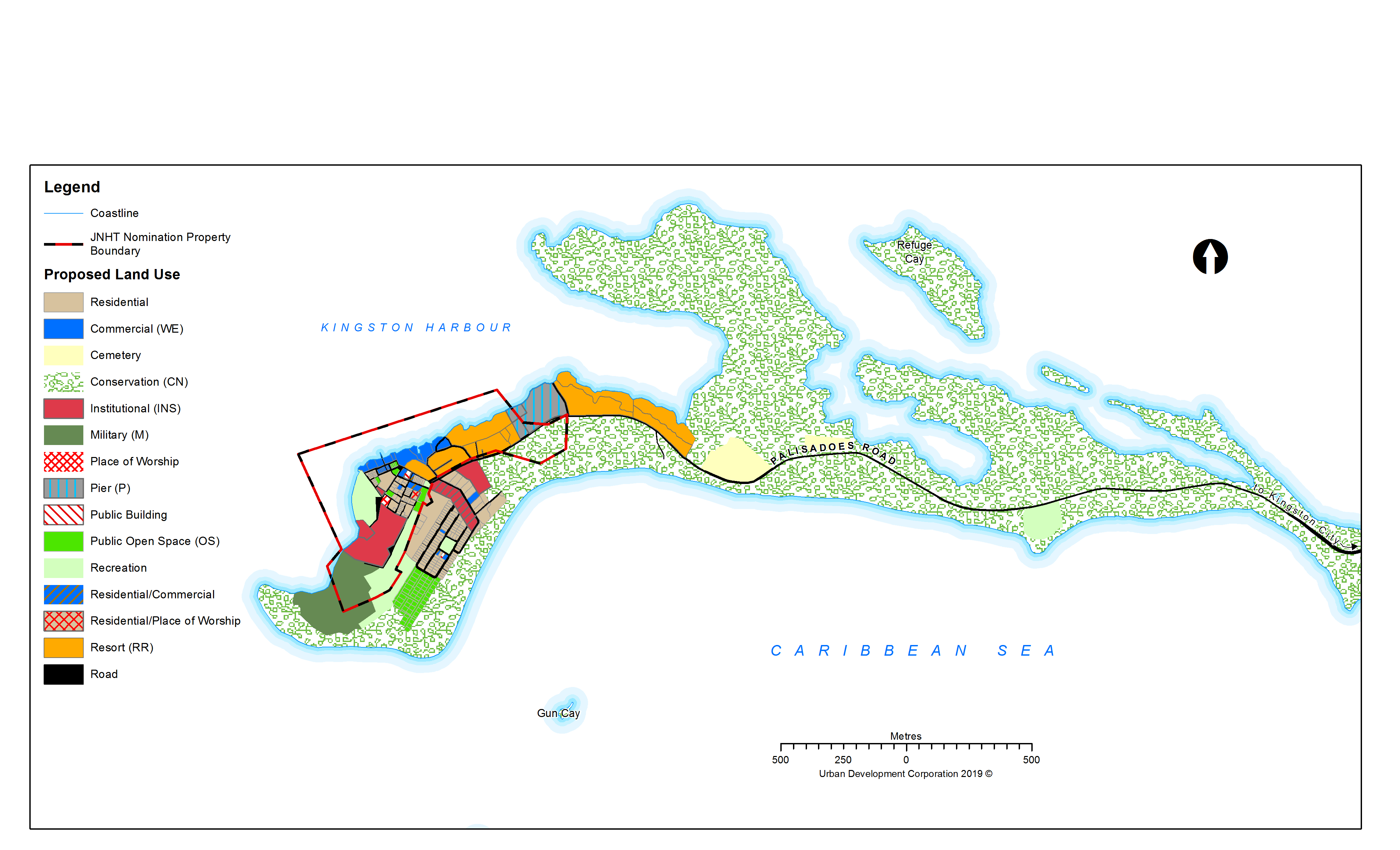
Map 4: Proposed land Use
Proposed Land Use Justification
The redevelopment area includes the tombolo that makes up the Palisadoes and serves as a natural protection of Kingston Harbour, all the Cays located in close proximity of the Port Royal site and the sunken city. The land uses captured, will only relate to those activities planned for the town and extending eastwards to Fort Rocky.
The guiding documents for the proposed land uses are:
- Town and Country Planning (Kingston and St. Andrew and the Pedro Cays) Provisional Development Order, 2017
- Draft Palisadoes-Port Royal Protected Area Zoning Plan 2014 – 2019
- JNHT’s Port Royal Nominated Property Boundary Designation Core
1.1 Recreational/Historical Site (HS1 – HS10) Area: 9 ha (22.24 acres)
This category captures the major areas within Port Royal that are slated for the development of attractions. Importantly, these areas are also of archaeological significance to the town constituting some of the main historic sites. The assigned zoning, highlight four (4) historic sites within the town.
- Fort Charles (HS1)
- Chocolata Hole (HS2)
- Lime Street (HS3)
- Historic Old Naval Hospital (HS4)
- Fort Rocky (HS11)
1.2 Military (M1) Area: 6.37 ha (15.73 acres)
This use relates to the site that is under the jurisdiction of the Jamaican Defense Coast Guard and serves as the base of the Coast Guard.
1.3 Institutional (INS1 – INS4) Area: 0.34 ha (0.84 acres)
This category consists of public facilities that provide educational and other social services and include:
- University of the West Indies Port Royal Marine laboratory (INS1)
- Caribbean Maritime University Campus related activities currently taking place within the H-Block Building. The existing use is subject to change based on on-going discussions.
- Port Royal Primary School (INS3)
- Port Royal Branch Library (INS4)
1.4 Residential (R1 – R4) Area: 10.47 ha (25.87 acres)
The use relates to all the existing and proposed areas for residential development. The areas included are primarily:
- The Brotherhood housing area, which comprises the oldest stock of housing within the town and includes a mix of apartments and single-family units (R1)
- The HAJ developed housing area (R2)
- The housing area along Michelin Avenue in the vicinity of the Old Barracks (R3)
- Proposed new housing area which will target low density luxurious resort-type housing development and which will be mindful of the sensitivity of the area, especially its environmental and archaeological importance. Unit type will range from studio to three bedrooms and of height no more than two storeys (R4).
In tackling the issue of housing will involve an approach with multiple options to include:
- upgrade existing
- demolish and re-construct new
- a combination of conversion, expansion and reconstruction with particular emphasis on:
a. increased density- more habitable rooms per acre
b. commercial opportunities which would include bed and breakfast opportunities
c. better quality urban environment
d. options for tenure
e. establishment of codes controlling setbacks, materials, heights and uses
1.5 Resort Residential (RR1) Area: 4.29 ha (10.61 acres)
This zoning includes the Morgan’s Harbour Hotel, which is targeted for redevelopment and expansion. It is recommended that the site be developed as a low-density five-star resort. The development of this block shall take into consideration plans for the Port Royal waterfront. This will extend from the eastern boundary of the Historic Royal Naval Hospital to include the existing Fisherman’s Beach as well as the northern portion of the Naval Dockyard lands, allowing for connectivity with the waterfront. Developments within this zone will recognise the existence of the significant historic site to include that of the St. Paul’s Church.
1.6 Pier (P) Area: 3.86 ha (9.55 acres)
This zone will consist mainly of a pier and terminal facility to facilitate the embarking/disembarking of cruise ships; and will also serve as a multiple use zone particularly on non-cruise ship days. Facilities within this zone will provide the main logistics and other pier/port related support facilities. Only one cruise ship with a passenger capacity of approximately 2500 person is envisaged to be in port at any one time noting the sensitivity of the town and surrounding environment.
1.7 Commercial (C1) – Waterfront Experience 1 & 2 Area: 1.56 ha (3.85 acres)
Uses within this zone relate primarily to activities dubbed “Waterfront Experience” proposed for areas within the existing commercial node of the town and extending along a redeveloped Port Royal Waterfront to include new commercial activities extending from the property boundary of the Historic Royal Naval Hospital eastwards to the Resort Residential Block of the Morgan’s Harbour development block. It is anticipated that a boardwalk will connect all the activities.
1.7.1 Waterfront Experience (WE 1) Area: 0.49 ha (1.20 acres)
The area will extend from the boundary of the Historic Royal Naval Hospital to that of the Old Naval Dockyard. Within this waterfront area will be:
- the-established Ferry pier
- the fisherman’s beach,
- a seafood market,
- the existing Gloria’s Restaurant,
- boardwalk,
- other commercial activities in support of the town.
1.7.2 Waterfront Experience (WE2) Area: 1.07 ha (2.65)
This zone extends the full length of the Naval Dockyard to the boundary with Morgan’s Harbour Hotel and will generally include:
- Seaside gourmet restaurants of fine local and international cuisine.
- Limited parking and transportation options for traversing though the town;
- Visitors Centre and Rest stop incorporating ticketing, exchange facilities, offices, toilets and a tourist board kiosk,
- Interpretive Centre with simulations dedicated to Royal Naval History, the Kingston Harbor and the Jamaica Coast Guard;
- New Ferry Terminal and Marina with Customs and possibly relocated Police Station;
- St Paul’s Archaeological Park and Craft Bazaar
The plan also recognizes other small commercial nodes within the town such as those along the Foreshore Road, which are generally patronised by the local population.
1.8 Conservation (CN) Area: 157.23 ha (388.52 acres)
This zone is adapted from the Draft Palisadoes-Port Royal Protected Area Zoning Plan and includes the majority of the Port Royal mangroves (inclusive of Refuge Cay) as well as the coastal scrub vegetation dune ecosystem located east of the town. Included in this zoning is the archaeological site of Fort Rupert, which is being proposed as an eco-park.
1.9 Open Space (OS) Area: 3.88 ha (9.82 acres)
This location will be a shared site and will also provide open space facilities to serve the needs of the town, which now takes place at Lime Street. Currently, the Lime Street Archaeological site provides this service. However, there are plans to excavate Lime Street around which an attraction will be developed.Proposed new housing area which will target low-density luxurious
Approach to Historic Revitalization
In developing the attractions, the focus will be on history, conservation and renewal. As such, development will seek to:
- Restore what is necessary to retain our history.
- Repair rather than replace; repair rather than restore
- Emphasise the celebration of architecture, history and skills of the people [Port Royal Street layout of a 17th century town – share their stories]
- Identify and implement sustainable solutions for adaptive re-use; also consider interim uses.
- Have a Management Plan for each building/attraction – This will be done in collaboration with the Urban Development Corporation, the Jamaica National Heritage Trust, and the Town & Country Planning Authority etc.
- Where not feasible, tell the story through storyboards and interactive exhibits the use of technology.
Development of Historic Sites and Attractions
These include surviving structures both above ground and those to be found below the ground and sea. There is a proposal to develop a Historic Trail for the cruise ship passengers and locals to include historic sites, archaeological dig sites, museums and interactive exhibits. The build-out of the historic sites into stand-alone attractions will also be considered. Port Royal represents a small seaside town located in one of the world’s largest and picturesque natural harbours on one side and the cerulean blue of the Caribbean Sea on the other. It is dotted with white sand cays; which boasts a history as the Pirate capital, the largest British Military base and one of the most important Maritime Ports of wealth and diversity in the New World; once known as the “wickedest and richest city in the world”.
While restoration is the preferred approach, ultimately what is done is dependent on the condition of the structures, the program to be developed along with its business plan and associated costs and the carrying capacity to be ascertained to ensure the protection and sustainability of the attraction.
It may be prudent based on the above to simply ensure the relic is structurally safe/sound and erect signposts and vibrant storyboards. Whatever the situation, it will require a case by case assessment in partnership with the JNHT and/or NEPA.
There are four main components to the development of the historic attractions:
- The restoration, adaptive reuse, reconstruction of relic and continuing cultural landscape and development into attractions or telling the story of the historical object/s and its development into an attraction
- Development and excavation of archaeological parks and sites
- Centre for Archaeology and Conservation Research with opportunity for links with tertiary institutions.
- Build awareness, appreciation, relevance and adoption into the daily lives of users, buyers, suppliers and all other stakeholder classifications.
Proposal for each attraction will include a:
i. Program for Development – which clearly elucidates objectives and strategies and guidelines as stipulated by UNESCO for world heritage sites
ii. Business Case with financial projections and justification for the program
iii. Carrying Capacity Assessment/Environment Impact Assessment for the attraction different from but factored into that for the town
iv. Operations & Maintenance Management Plan
v. Marketing Proposal/Plan
vi. Architectural Impact Assessment
vii. Heritage Impact Assessment
viii. Sound and Light Study
ix. Watching Brief
Development strategies for successful, sustainable attractions could include:
The development of tour packages linking a series of related attractions- ‘heritage trail’ in keeping with the Tourism Action Plan (TAP) to ensure the best exposure and a more fulsome experience.
- Expanding linkages to other sites in the corporate area – Kingston/Spanish Town/Port Royal Links such as:
- Protected Area Links and Excursions – Port Royal and Palisadoes, Portland Bight Protected Area, Blue and John Crow Mountains World Heritage Site
- Military links – Port Royal, Up Park Camp, New Castle.
- Churches: St Peter’s, St Paul archaeological site, Kingston Parish Church, Coke Methodist, Jewish Synagogue, Holy Trinity, Cathedral of St James…
- Music and Entertainment to include Bob Marley, Peter Tosh, Trench Town ending at Fort Rocky
- Identification of important and/or infamous persons and events in Port Royal’s history from which to create a festival or special occasions (JNHT’s Annual Earthquake Awareness, June 6th each year) and from which to generate a Calendar of Events as a tool to invite the world to participate in Port Royal. Further linkages could be made to other locally already established events so that the richness of the Jamaican culture can be truly experienced.
Creating a Calendar of Events give the visitor a base to plan around, the operator a valuable marketing tool and affords Jamaica greater international recognition. - Daily scheduled enactments and simulations as a part of the attraction or town activities fostering inclusion.
- Generation of a full day of activities based on the environmental and historical value of the town. This would not only encourage return visitors but also create a demand for stop overs
- The creation of gift/souvenir shops for each attraction with sales of piece specific to each site created by the local cottage industry.
- Hire Jamaicans – hiring Port Royalists incorporates local stakeholders in the success of the development.
- Movements – part of the experience will have to include how visitors travel from one location to the other. Vast areas of parking, long lines on traffic will not be in keeping with the Port Royal experience; plus the potential negative impact that this could cause the environment demand that a strategy be explored and developed. Multi modal links offers the potential for accessibility via both land and sea (ferry).
a. Park and ride shuttle
b. Park and ride ferry
c. Limited on-site parking
d. Electric trams or carts
e. Bicycle tours
f. Walking tours
Plate 1: Proposed Historic Trail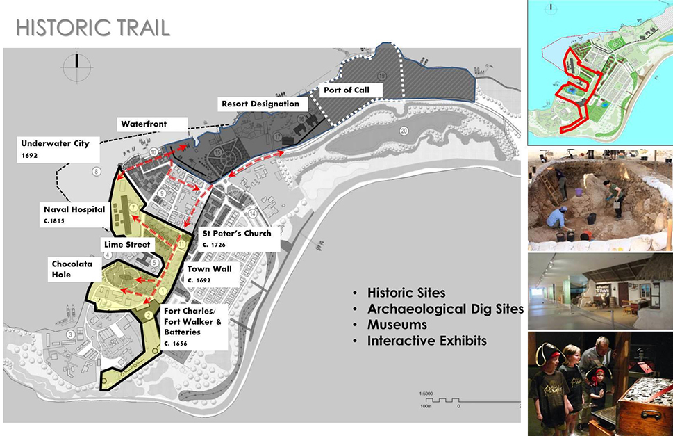
Plate 2: Development of Fort Charles & Fort Walker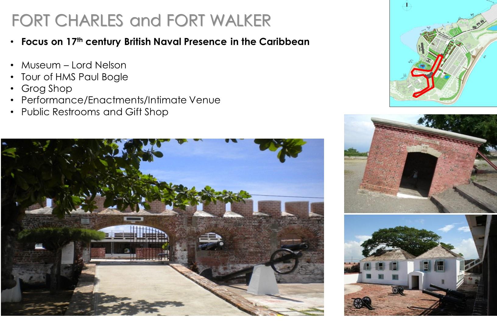
Plate 3: Reimagining the Historic Royal Naval Hospital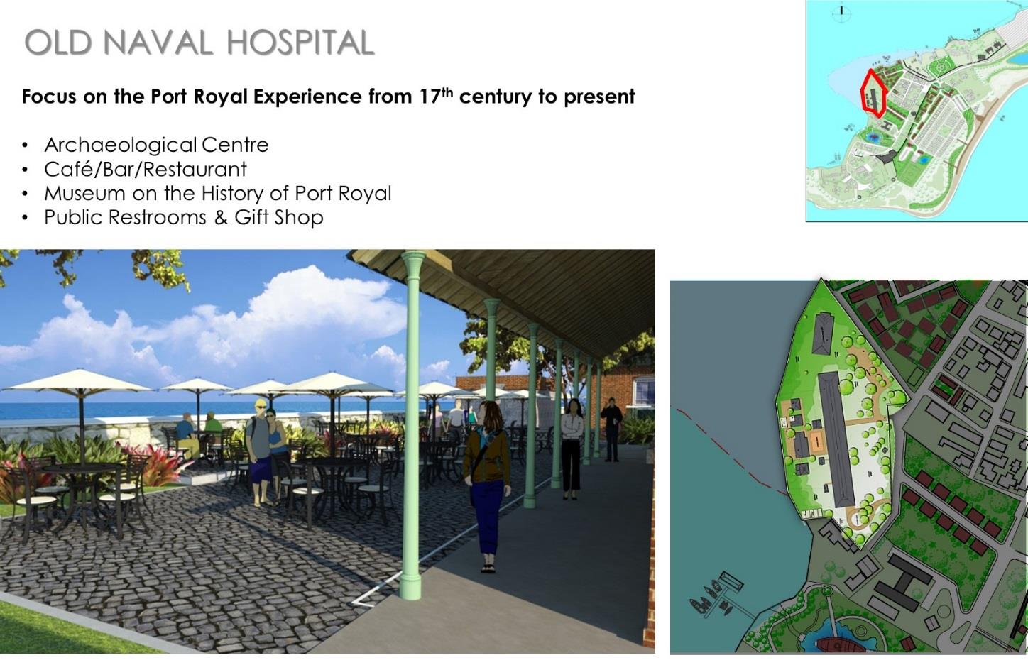
Plate 4: Lime Street Development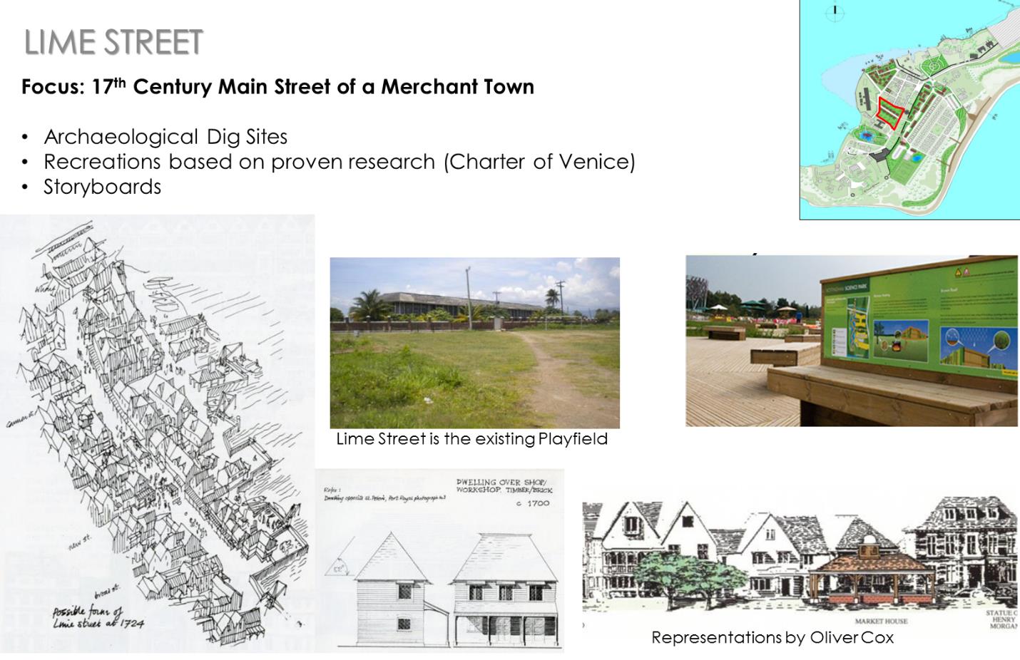
Plate 5: Fort Rocky Entertainment Zone Redevelopment Proposal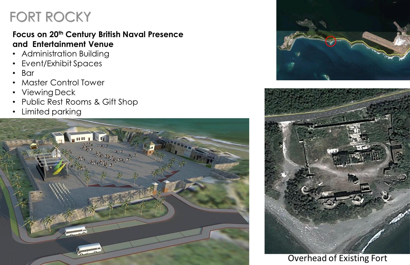
Development of the Port of Call
A. The preferred location for a Port of Call is at the Old Coal Wharf. The site itself is of limited historic value, located just outside of the designated core of the town and at the edge of a sensitive conservation zone. An archaeological and environmental assessment will be necessary however to ensure its suitability at that location.
The Port of Call would be beneficial in providing a guaranteed customer base for Port Royal as a destination, but there is a danger of overwhelming the site. Thus carrying capacity assessments are being considered and the process to undertake the task has begun. This will be based on usage and for the long term involving detailed assessments as is required.
B. Typical cruise ports include a pier structure accompanied by a basic arrival facility to facilitate offloading/on loading to/from shore excursions. Given these significant investments, developers would often try to get as much surrounding real estate (for destination development) as possible to optimize returns in the short, mid and long terms.
C. Port Royal, as a port destination will be limited given the sensitive nature of the site and the finite land resource that exists and that may be needed for the attractions, the environment and the existing population. Out of concern for the impact of large arrivals, the cruise liners that will call at this port will be limited to 2,550-3,000 passengers per visit. This may not be an issue as the increasing trend is expanding from a basic pier structure to comprehensive day destinations with entertainment, retail and dining facilities.
D. The concept of linkages is relevant here as well. We shall explore having a floating pier with a limited Port of Call at Port Royal, which would be the main draw. It will include tendering capabilities from the ship to larger more comprehensive alternate port facilities across the harbour at Kingston to accommodate more efficient loading and offloading and multiple excursions.
Sterile environment and customs with any port of entry would be accommodated in the arrival facility. While there would be limited excursions out of the Palisadoes area, the primary focus would be Port Royal via sustainable mobility options (articulated carts, electric carts, bicycles, segways and walking; all alternate, innovative low impact modes of transportation rather than the larger tour buses. Tour buses for excursion outside of the area would park and then ride using these alternate modes (will be part of an elaborate dispatch system).
Housing Development
Approach to Housing
The current housing demand is to be ascertained. The UDC sought and received costings and TOR to undertake a housing survey in Port Royal. In the interim, there are clear guidelines on an approach to housing and the built environment going as far back as in the 1987 Development Proposal document. At that time the same issues we are grappling with now, existed then. If we are not to find ourselves in the same situation once again, a radical paradigm shift with how we deal with settlements in Port Royal given the constraints on building and available land is needed.
The 1987 approach to the built environment can be summarized as follows:
- That the town retains its present pattern, with a main focus on the fishermen’s beach. Tidying, upgrading and infilling to be undertaken in a manner that reflects the town’s history and improves its usefulness to the people who live there;
- That historic buildings be sign posted, cleaned up and displayed so that they can be more easily reached and their story understood by the public;
- That historic buildings and streets be reconstructed on their original sites where these are free of buildings, and used to provide work and homes for the existing population and accommodation for visitors.
- That selected areas on land and sea will be designated for untroubled excavation, investigation and, where possible, exhibition of such historic relics as may be located there.
- That services in existing buildings be updated and, where appropriate, architecturally ‘camouflaged’.
- That a small segment of the town be reconstructed in such a way as to give visitors an impression of what Port Royal might have looked like today if buildings from the various stages of its history had survived over the centuries.
The proposed programme of refurbishing, revitalization and new construction must, take account of archaeological explorations at each phase of development. Because the site is special and vulnerable, and so as to fully realize the project potential, archaeological exploration and monitoring must precede every aspect of construction activity, be it pipe laying, building construction, modifications to existing buildings or marine activity.
This should not be regarded as a disadvantage. Potential investors should consider the following:
- That archaeological investigations and excavations are in themselves prime tourist attractions.
- That international policy towards archaeological investigations is that such works proceed upon the principle of ‘Least intervention’ in the affected developments.
- Technological and skill transfer to Jamaican archaeological interest and/or team members for future work in Jamaica will be considerably enhanced, thus shortening the time this investigation takes. (1993).
Guidelines for Housing in Port Royal
The constraints to building in the town of Port Royal include the following:
- General exposure to strong winds during hurricane season (June-October)
- Soil liquefaction during any major earthquakes. Some areas of the town have historically been more prone than others.
- Potential for flooding during hurricane season and seasonal tidal rises.
The central area of Port Royal appears to be the most stable for building. For the purposes of development zoning, Port Royal has been given three ratings for construction purposes: Reference to housing capability in Port Royal is made in our base document Marvin and Goodman and Associates, 1993 to guidelines as stated below. See also Map 5.
A: Fully normally loaded 2 storey structures, normal spread footings or raft sufficient subject to SPECS Max 3 Storeys permitted.
B: Site Investigation Mandatory for any 2-3 storey structures Special foundations required.
C: Unconsolidated area no permanent structures to be constructed in this area.
D: No Structures.
In all cases, and based upon engineering recommendations, all structures should be designed with overall symmetry in mind, both in layout and loading. The California Earthquake Codes (SEAOC) is relevant for Port Royal.
The existing historic structures in Port Royal today give many clues to the approaches that should be adopted in the building, design and construction in Port Royal:
a) In all cases, roofs are lightweight, steeply pitched and well anchored down directly to walls or frames
b) Walls are well braced in all directions
c) Structures are simple shapes and roofs allow for air circulation
d) No eaves or long projections
e) In some cases, e.g. the Historic Royal Naval Hospital and the Barracks, walls are structurally separated from roofs to spread loads.
f) Principal floors are elevated off the ground
g) Timbers are high quality and larger than standard size and used on the upper floor only
h) Shutters and louvres are preferred to glass windows and doors
i) Structures often oriented east-west and fully shaded veranda’s provided
j) Toilets raised above ground level due to high water table
Population to House in Port Royal
Conclusions can be drawn from assessments of the characteristics of Port Royal’s population, to determine the types of housing that will be provided for its residents. Analysis of the 2011 population figures indicate that Port Royal has a population of approximately 1,251 people with a near even split between the number of males and females living in the town; 618 males and 633 females.
The population in Port Royal decreased since census year 2001, with a 24.27% decrease between the years 2001 to 2011. The decrease in population over the census periods can be attributed to employment opportunities and more significantly, availability of adequate housing facilities in the town.
Housing Provision to Accommodate the Population
In Port Royal, a large percentage of the population live in inadequate housing facilities and this is compounded by inadequate infrastructure and services. Consideration must also be given to the fact that the current overcrowding is largely due to multi-generational households. Although population is decreasing this phenomena continues to be a reality with each housing assessment completed over the years. Thus some amount of flexibility or evolution has to be factored in the way forward.
In 2000, Peter Francis, RA JIA for the Port Royal Development Co Ltd., completed A Housing Study for Port Royal. Which acknowledged earlier reports such as ‘Upgrading and Renewal Plans on Port Royal, by Oliver and Jean Cox, 1984 and 1987’ and the ‘Report on Development Issues for Port Royal and the Palisadoes by Marvin Goodman & Associates 1992’ and confirmed the existing areas within the Historic District, controlled by the Brotherhood being the most stable area geologically. The Foreshore Road also called Beach Housing built in the 1960’s-80’s by the National Housing Corporation consisting of single storey semi-detached units are located on sandy soils with the site generally exposed to strong easterly winds for which they have suffered over the years. An approach option of:
- Upgrade existing
- Demolish and re-construct new
- A combination of conversion, expansion and reconstruction
i. with particular emphasis on:
ii. increased density – more habitable rooms per acre
iii. commercial opportunities which would include bed and breakfast opportunities
iv. better quality urban environment
v. options for tenure
vi. establishment of codes controlling setbacks, materials, heights and uses
A proposed phasing strategy was elaborated starting with upgrade and reconstruction of housing units by Michelin Avenue, which consists of two remaining officers’ quarters from the turn of the century [Elizabeth and Trought] to a total of five [reconstruction of Gibson and Peel and one new construction] which would provide some housing while those in the town are addressed. Meanwhile in the town, Brotherhood units would either be upgraded or reconstructed depending on their condition.
This 2019 Master Plan suggests that given the constraint of suitable sites for housing, and the condition of the current housing stock, that densification of the existing sites to that of substantive period of the town [17th century] is the best solution. This would entail option ‘3’ of conversion, expansion and reconstruction mentioned earlier. This approach should be in keeping with the historic precedents of two-plus storeys in a form, massing and material that is typical of the period. Keeping in mind the 1968 UNESCO Proposal indicated that it would be ‘too ambitious, costly and subject to too much conjecture’ to rebuild the whole town.
This approach to increased densities would seek to maintain the integrity of the town, while offering opportunities for growth and economic realization for its residents. Once achieved however, expansion is finite legislative, management solutions will be necessary to ensure the issues of overcrowding, and blight does reoccur.
Any increased densities would entail units of two floors plus attic in height and would use typical 17th century structures for precedents in both aesthetic and material usage. The recommended approach to achieving this would be one of conversion, expansion and reconstruction starting with the Brotherhood apartment blocks. if upgrade is still feasible, the option of the Ill de France conversion prototype is still available. This includes reconstruction then a combination of one, two and three bedroom housing solution around upgraded internal amenity spaces. This will be done in the existing 17th century street layout. The provision of a pre-approved conversion or expansion of similar form for owners of the single story flats and cottages, which would offer a viable opportunity for additional rental income, or development of a bed and breakfast for visitors.
Individually owned houses in the area are currently apartments. For the most part using the existing 17th century street layout and providing a combination of one, two and three bedroom/s.
Source: Marvin Goodman & Associates, 1993Map 5: Guidelines for Housing Development – Site Vulnerability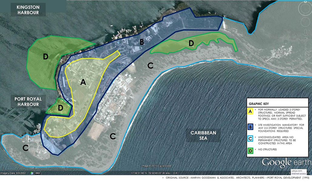
Graphic Key
A: Fully normally loaded 2 storey structures, normal spread footings or raft sufficient subject to SPECS Max 3 Storeys permitted.
B: Site Investigation Mandatory for any 2-3 storey structures Special foundations required.
C: Unconsolidated area no permanent structures to be constructed in this area.
D: No Structures.
Economic Opportunity
The lack of economic activity in Port Royal is in stark contrast to the potential of the location. The development of the historic attractions and the Eco potential of the Natural Environment along with that of the Waterfront or Fisherman’s’ Beach is to be the vehicle for its creation or transformation into a vibrant economically viable community.
The Fisherman’s Beach, located between the Naval Hospital and the Naval Dockyard is the official location for the fishermen to dock, fuel up and bring in their catch. Gloria’s Restaurant along the same strip is the only formal restaurant specializing in seafood, which over the years has not only survived but also expanded. The Port Authority of Jamaica had indicated the continued demand for marinas for safe secure docking facilities for pleasure boats.
The Port Royal Waterfront, located in the calm waters of the Kingston Harbour is poised to take advantage of these opportunities. These include:
- Development of a fishing village to feature the gastronomical delights of its produce.
- The expansion of the inherent maritime culture to incorporate yacht, marina and waterborne developments.
- Activities geared at experiencing an environment rich in the history of military exploits, piracy, and high drama.
- The entrepreneurial aspirations of those willing to take up the challenge of developing cottage industries to support it this new economic activity.
Proposals for the waterfront include:
- Fisherman’s Beach and Fish Market,
- Seaside restaurants,
- Specialty shops and
- Other commercial activities in support of the town and the town community.
This new public waterfront would be linked from the Historic Royal Naval Hospital site through the Royal Naval Dockyard to the Morgan’s Harbour Hotel site by a public boardwalk.
Eco Tourism Development
Eco Tourism is a form of tourism which involve visiting fragile, pristine, and relatively undisturbed natural areas, intended as a low-impact and often small scale alternative to standard commercial attractions. It means travel to natural areas, conserving the environment and improving the well-being of the local people. Its purpose may be to educate the traveller, to provide funds for ecological conservation, to directly benefit the economic development and political empowerment of local communities, or to foster respect for different cultures and for human rights.
Since the 1980s, environmentalists considered ecotourism, so that future generations may experience destinations relatively untouched by human intervention. It typically involves travel to destinations where flora, fauna and cultural heritage are the primary attractions. It is intended to offer tourists an insight into the impact of human beings on the environment and to foster a greater appreciation of our natural habitats.
Responsible ecotourism programs include those that minimize the negative aspects of conventional tourism on the environment and enhance the cultural integrity of local people. Therefore, in addition to evaluating environmental and cultural factors, integral aspects of ecotourism are:
- Carrying capacity evaluation
- the promotion of recycling
- Energy efficiency
- Water conservation
- Contributes to climate change mitigation and adaptation
- Creation of economic opportunities for local communities.
For these reasons, the target market is often advocates of environmental and social responsibility.
Recreational Activities
Recreational opportunities in Port Royal are primarily water- based with some landside links. The challenge is to regulate these activities, bring them to acceptable public standards for which safety, and access and the formalization of the linkages to similar sites in adjacent areas. The activities, which may or may not exist, have the potential to be developed further are:
- Swimming ( Gun Boat Beach)
- Diving and snorkelling
- Recreational fishing
- Pleasure boating, yachting (Royal Jamaica Yacht Club, Morgan’s Harbour Hotel Marina)
- Entertainment events at Fort Rocky Entertainment Complex and Historical tour
- Excursions to the cays, around the Kingston Harbour
- Harbour activities such as kayaking/canoeing, jet skiing, both motorized and non-motorized sports.
- Camping and the general enjoyment of the open spaces (including possible use of Fort Rupert). The entire Caribbean Sea frontage, extending back to the main road is designated public open space, containing two beach areas and parkland. The lagoon at the entry to Port Royal is to be landscaped as a picnic area and the position of Fort Rupert marked.
- Continuation of the Waterfront Promenade into the Malecon concept of a continuous pedestrian zone to Port Royal with various points of interest, attractions, rest stops, businesses along the way while encouraging walking, jogging, cycling, etc.
- Hiking in the Blue & John Crow Mountains
- Rockfort Mineral Spa and Fort
- Mountains Sporting events at Sabina Park, National Stadium
- National Heroes Park, Hope Botanical Gardens
Linkages with other Attractions and Communities
The University of the West Indies (UWI) Marine Laboratory is located amidst the sites for Lime Street, Chocolata Hole and the Historic Royal Naval Hospital. It is primarily a research and development facility, focused on marine life in the Kingston Harbour and its Environs. In 2010, their focus was on the mangroves and their rehabilitation. The Marine Lab offers educational opportunities for students and individuals who are interested in the marine environment by providing tours through the mangroves and other educational excursions along the harbour. There is a Biodiversity Centre hosting interactive exhibits to facilitate continued interest and learning. A package can be arranged where meals and refreshment are included in the day’s activities.
The entire mangrove is to be set up and operated as a Marine Park extending from Port Royal to the airport and encompassing Refuge Cay and all boat refuges. The unsupervised incursion of boats and people into the mangroves is to be strongly discouraged.
Guided tours through the mangroves and along the Palisadoes will be organised and carefully gauged to keep the impact to a minimum. Consideration is being given to allowing the management offices of the Marine Park to provide oversight of the natural environment of the protected area implementing both the Zoning and Management Plan of NEPA.
The creation of a Palisadoes Marine Park, to operate as and continue research with the UWI Marine Laboratory will provide the vehicle to bring solutions to the identified problems. As with the development of the historic attractions, a body for oversight, approvals and monitoring is necessary to safeguard these initiatives.
General upgrade of the Palisadoes in keeping with a national park environment will include elements of security and safety due to the extensiveness of the areas and proactive management. The responsible facilitation of active and passive recreational activities, eco- attractions will further strengthen Port Royal as a prized destination.
Port Royal Town Upgrade & Supporting Amenities
Infrastructure Upgrade
To facilitate the transformation of Port Royal into the cultural heritage eco-tourism product we envision, it will be necessary to upgrade the existing infrastructure, and facilitate adherence to a sustained Town Management and Maintenance Plan. It is also necessary to confirm the carrying capacities for the town, the attractions and address the following issues.
Solid Waste Disposal and Collection -To include daily refuse collection and the appropriate environmentally aware programmes to be put in place such as recycling, proper disposal, strategic placement of waste receptacles etc.
Electrical Supply (JPS) – 4KV from airport, which causes fluctuations of voltage in Port Royal to be Upgraded Coast Guard, has Stand-by Generator. Streetlights in the town to be of period (17th, 18th Century) – underground where feasible.
Telecommunication – Cabling and upgrade of landline and cell phone facilities will be implemented as is required in the town, after provider assessments.
Road Works & Storm Water Drainage
General upgrade of road surface and drainage from airport round about to town. Once the analysis of movement options is complete, the roadways will be upgraded to facilitate.
Road works are to include the application of public standards to streetscape in the town to make it pedestrian friendly. In the town, there is a network of open drains; a system of non-return flaps prevents sea water from flooding the town during storms or high tide. Waste water flows from open channel in the housing yards to channels under the sidewalks. They fall to larger at either side of the town which fall to the harbour but often become blocked.
Water Supply Upgrade (NWC) – The population in Port Royal is 1,251 persons (2011 census) with an expected increase of up to 6,000 persons per day with the expansion of the hotel and installation of the port. The capacity of the existing NWC facility needs to be assessed to determine its capability to service the increased demand. Though this increase is not a permanent increase, the temporary spike will be considered to ensure the supply is adequate.
This is also be a good time to look at the supply main from Harbour view. The supply main was upgraded in the upgrade of the palisades corridor from Harbour View to the Norman Manley International Airport round-a-bout. The main lines from NMIA to Port Royal were not upgraded.
Map 6: Proposed Water Distribution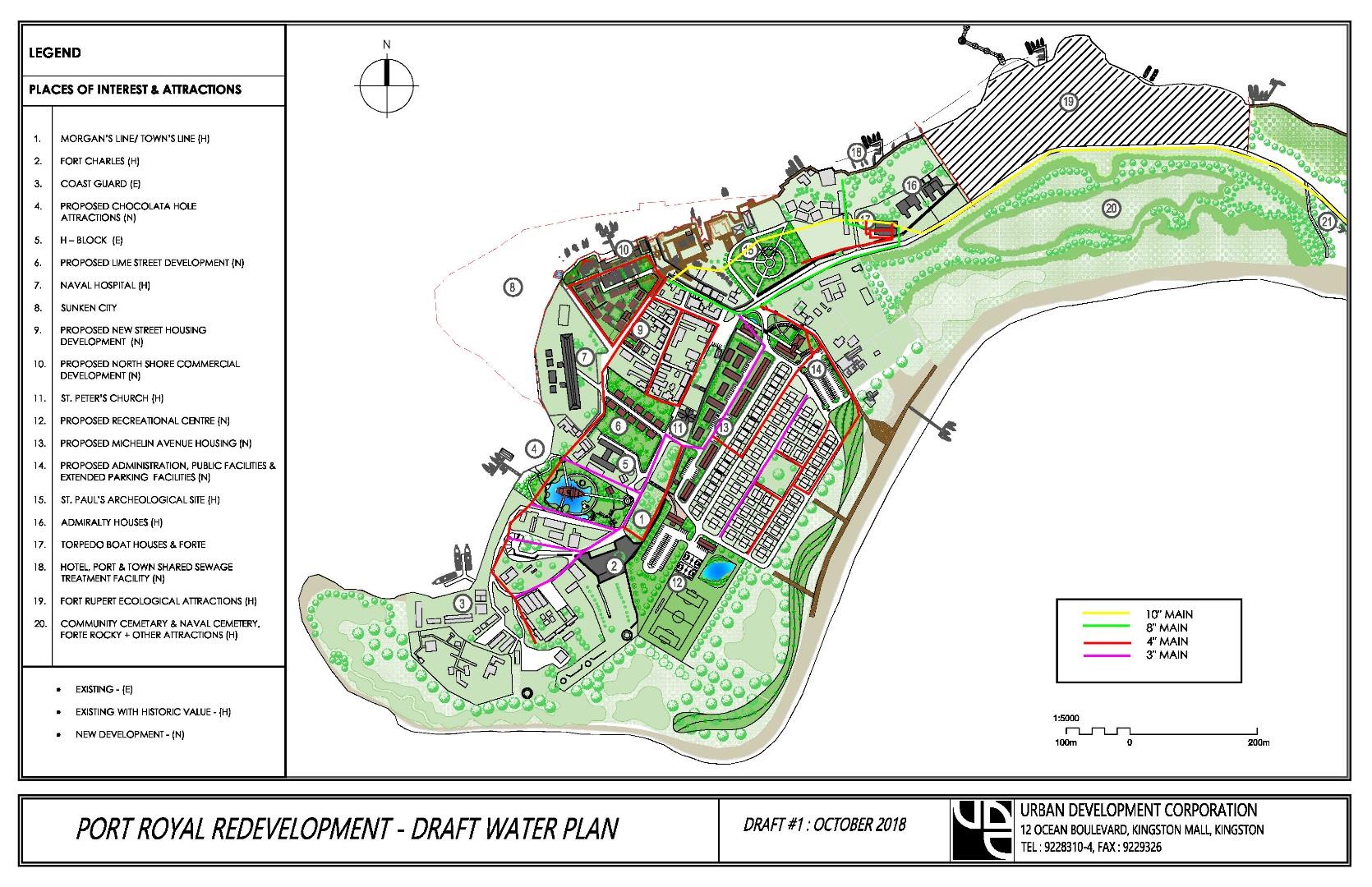
Central Sewerage (NWC)
The sewage infrastructure in Port Royal is dealt with in two main ways: on-lot sewage treatment and centralized sewerage. The on-lot sewage treatment involves connecting to an individual or shared septic tank. These septic tanks provide primary and secondary treatment and is then connected to a soak-a-way. A site visit of the area was conducted and majority of the septic tanks located, however the soak-a-ways were not identified.
Centralized sewers are located within the HAJ development which conveys to two wastewater facilities. We are still gathering information on the details of this system as well as the network. We have observed two sewage structures at the south west and south east of the community. We have also noticed an over flow from the system which would indicate a malfunction of this system.
The naval base also has centralized sewage and a lift station that conveys to an onsite treatment plant. However, their treatment plant is not functioning properly.
Concept
The concept in summary is a network of gravity sewers, which convey to two lift stations (See Map 7 ) and the pump to the new treatment, which is proposed to be located on the property that will accommodate the port development. Two lift stations will be utilized, one in the north section (beside the post office) and the second one to replace the malfunctioning HAJ plant. The concept conveys the sewage east from the Harbour’s coastline to lift station 1.
The maximum pipeline excavation is expected to be about 1.5m (5ft). The HAJ development is already sewered and we would invariably capture those sewered flows into lift station 2 at the back of the general proposed recreational area.
The concept also makes provision for agencies such as Coast Guard, CMU, Police station, School and restaurants to connect to the system. The connection of restaurants and homes, retrofits will also be needed on an individual basis to provide grease traps to prevent its inclusion in the system.
Map 7: Proposed Sewerage Treatment and Disposal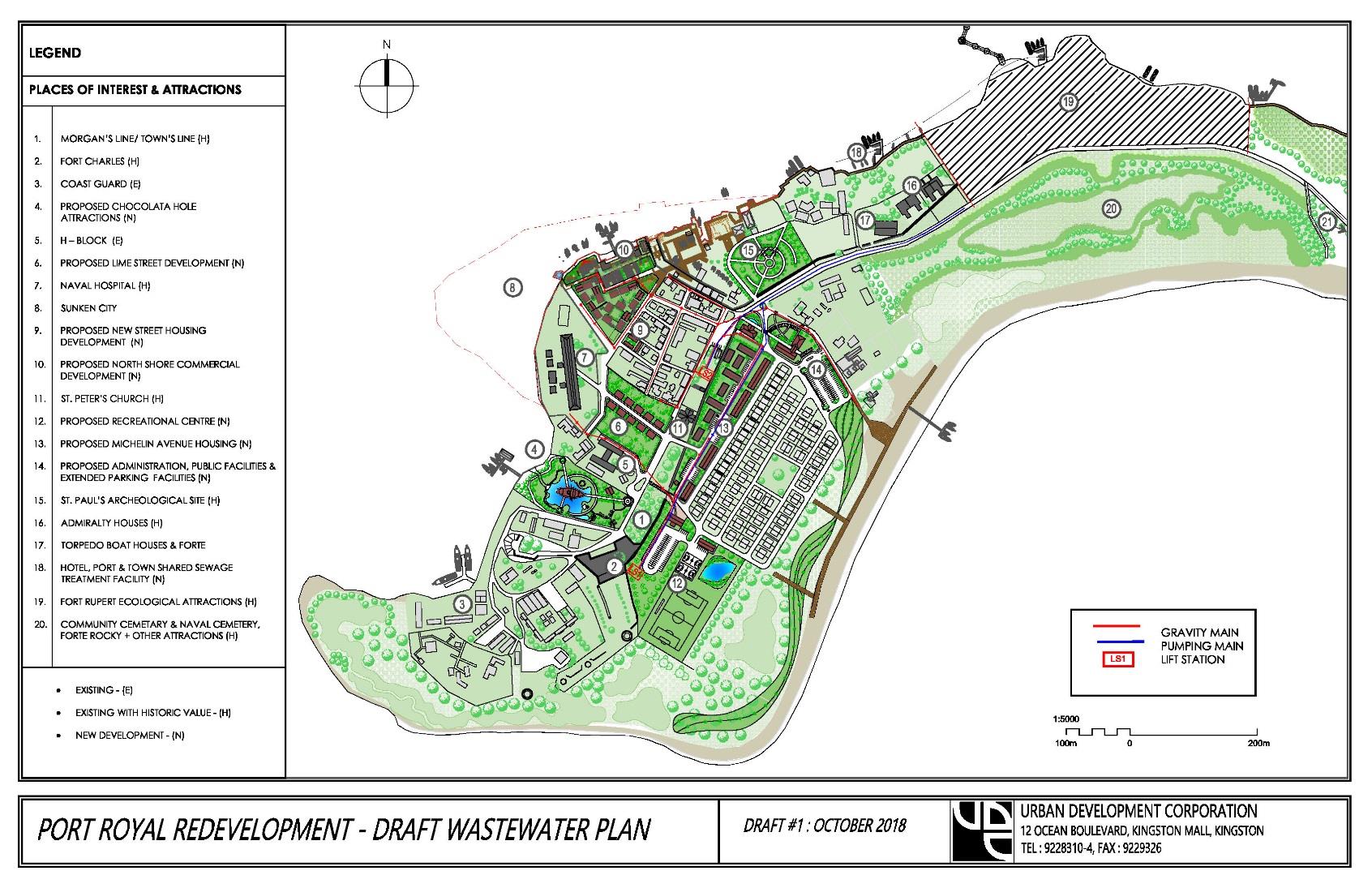
| Treatment Units | Required Area (Estimated) | Pros | Cons |
|---|---|---|---|
| Septic tank + Reed beds | Septic tank = 162 m2 Reed Bed = 1391 m2 Total = 1554 m2 | Low capital cost Less initial capital Minimal maintenance No power consumption Can be resistant to shock loads | Uses significant land space Reed require regular harvesting |
| Extended Aeration (Activated sludge) | Aeration tank = 158 m2 Clarifier = 20 m2 Chlorination = 5 m2 Total = 183 m2 | Uses less land space More stable and consistent treatment Easy nitrogen removal | Highest capital cost Requires regular maintenance Significant power consumption Possible odours |
| Oxidation Ditch (Activated sludge) | Oxidation Ditch = 158 m2 Clarifier = 20 m2 Chlorination = 5 m2 Total = 183 m2 | Uses less land space More stable and consistent treatment More resistant to shock loads Easy nitrogen removal | Higher capital cost More mechanical Requires regular maintenance Significant power consumption Possible odours |
| Stabilization Ponds | Anaerobic pond = 215 m2 Facultative pond = 3010 m2 Maturation Ponds = 860 m2 Total = 4085 m2 | Low capital cost Minimal maintenance No power consumption Resistant to shock loads | Most significant footprint Open water hazardous Possible odours |
Public Amenities
Public amenities add to the quality of life of its citizens and enrich the experiences of its visitors as they partake of the unique culture of the local community. The schools, the libraries, community centre all are valuable parts of the town fabric, not to be isolated or excluded from the overall experience, but they represent the life and culture of the residents. Thus, the general upgrade of infrastructure should be complemented by the addition, renovation and upgrade of the public amenities and services.
A. Playfield – the current playfield is located on the archaeological site we know as Lime Street found between Fort Charles and the Historic Royal Naval Hospital.
B. Community Centre – to complement the playfield and to act as community space for the residents.
C. Public Open Space – is a necessary part of quality urban living. It can be defined as the pars of a town that are available for the public to see, use and enjoy. They create a sense of community, provide a gathering space, a place for public life; they connect us with nature and to one another; they provide a place for entertainment, leisure, recreation and enhance the image of the community. Large areas of the southern and eastern sections of the Palisadoes Spit are designated as open space due to the unsuitability of this area for permanent structures. These areas should be extensively planted to provide recreational and relaxing spaces for the town.
D. Central Sewage – The recommended locations for the central sewerage plant can be seen on map 7.
E. System of Solid Waste – Management to include collection and disposal on a planned basis.
F. Fire Station – to be upgraded and regularized as the existing fighting unit historically has been intermittently out of service. The Jamaica Defence Force Coast Guard is said to have a fire-fighting unit which provides an
emergency service for the town. It is recommended that a mobile tender and a network of fire hydrants serve the town.
G. Health Centre Upgrade – the existing Health Centre is a type I facility with a resident nurse and a visiting physician. The recommended upgrade entails additional accommodations, a resident physician and ambulance linked to Kingston hospitals. A site for relocation will be decided based on consultations with the relevant agencies.
H. Post Office (Kingston1 designate) will be upgraded as required and in keeping with government policy direction.
I. Custom House – currently located on Fisherman’s Beach. A site for relocation will be decided based on consultations with the relevant agencies.
J. Police Station – part of East Kingston Division currently located on Fisherman’s Beach is to be relocated to a site that will be agreed through consultation with the relevant agencies.
K. Additional – Banking services/ATM – Financial institutions will be invited to assess and determine their presence in the town.
L. Local offices – for Oversight Committee, Tourist Board, Political Representatives etc.
M. Ferry System – to supplement existing bus system and as an alternate mode of transportation. Originally to be located by Naval Dockyard but possibly can be located by Cruise Ship Pier. It is expected that there will also be alternate tenders to carry passengers to alternate attractions outside of Port Royal, but the potential conflict between local and visitors is yet unclear.
N. Schools – [Basic and All Age) may require upgrade or refurbishing. The use of the H Block located by Lime Street and Chocolata Hole by the Caribbean Maritime University should be considered for possible future use as it represents a successful adaptive reuse of a town structure.
O. Public Library – is located on Broad Street and will be assessed to determine the need for upgrading and provision of additional services.
Public Standards
Port Royal is a perfect walking destination given that most of the major historic attractions are within 400m or a 5 min walk from each other. However, given the town’s climatic regime of extensive sunny periods, low rainfall and exposure to wind, the landscaping strategy will be of primary importance to the comfort levels of both residents and visitors.
One of the goals of setting Public Standards is to enhance the pedestrian environment and thus improve on the visitor and local experience by facilitating pedestrian activity and the 5 minute walk. Therefore, it is recommended that where possible the following should be applied (subject to archaeological investigations):
- Comfortable walking surfaces – low impact or minimal disturbance of soil below. Attention must be given to the finish of the sidewalks for ease of walking and to accommodate the elderly/physically challenged, accessible ramps; maintaining clear pedestrian right of way, separate from zones for utility/signage/street trees will be installed.
Shading is important, a system of wooden planters devised by UDC to avoid potential destruction of relics below the ground by tree roots is recommended; appropriate wind breaks in affected areas. Street trees provide shade and aesthetics while promoting walkable environments thus healthy lifestyles; protect pedestrians and provides a sense of closure to the street space; reduce heat island effect; absorbs storm water and airborne pollutants and increase surrounding real estate value.
The walking facilitates promotes local economic activity, adds to the life of the street, facilitates street activities and enhances public comfort and safety and results in a healthier nation. To encourage and facilitate a comfortable space the following strategies will be utilized.
- Use of indigenous plants; such as the coconut which was first introduced to Jamaica in Port Royal, several species of cacti, sea grapes, sea almond and continuing research to identify the addition of complementary species
required to transform the public space. There is also the potential to create a Nursery for the sustainable management of public planting. - Benches, signage (location, direction and story boards), garbage receptacles, light poles, banners and other site furnishings.
- Controlled Parking – limited on-site parking for residents and employees as well as off- site parking for visitors with a system of alternate modes of transportation, including cycling.
Development Concepts & Proposals
Plate 6: Overall Development Concept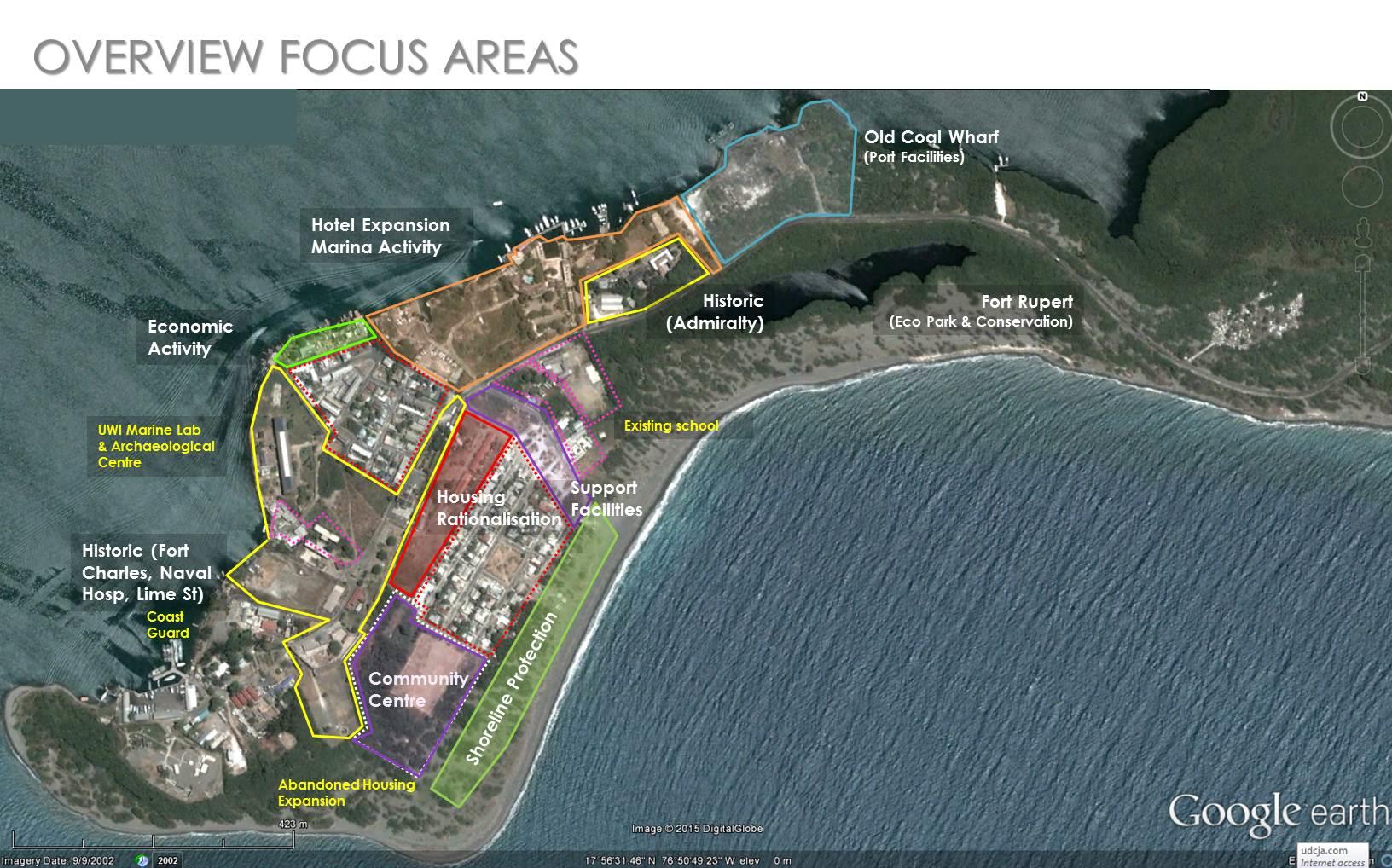
Plate 7: Proposed Housing Expansion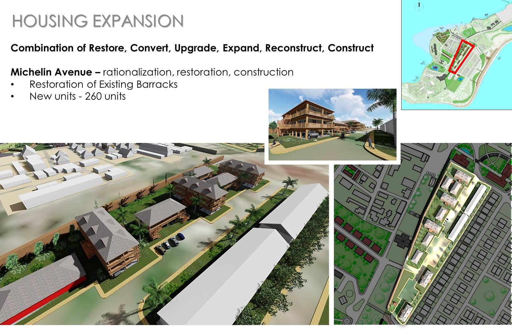
Plate 8: Proposed Economic Activities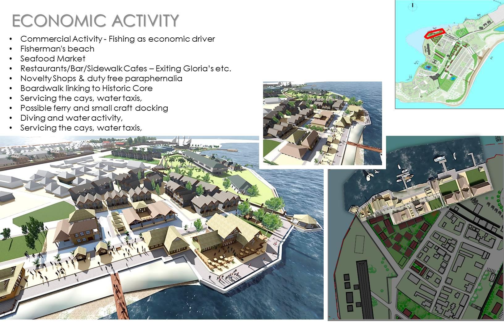
Plate 9: Proposed Community Centre Development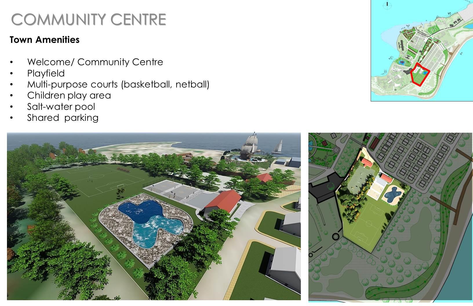
Plate 10: Proposed Supporting Facilities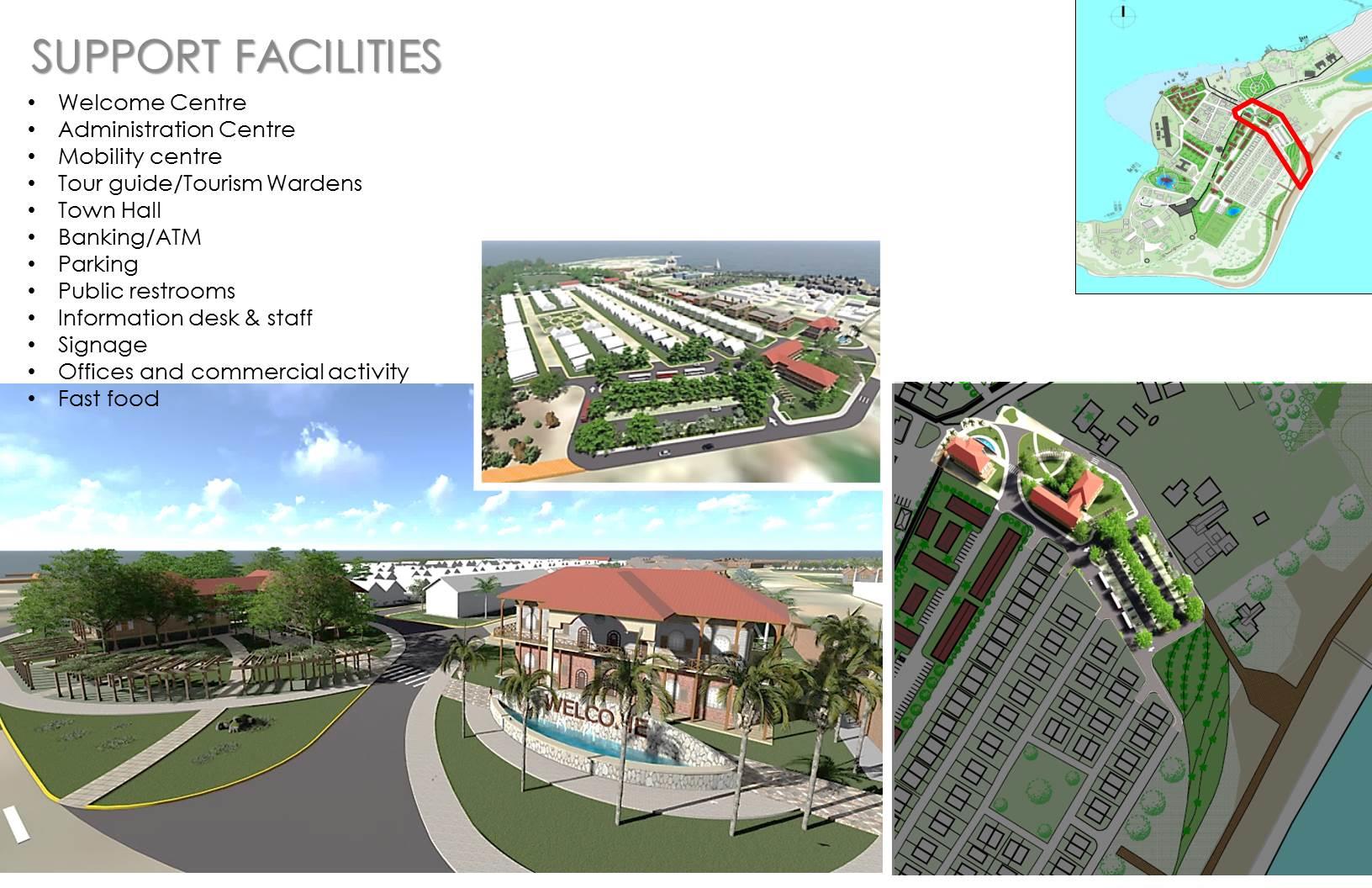
Development Oversight
Special oversight is required to vet and facilitate the developments/attractions given the nature of the development area. This must entail an entity with members from key regulatory agencies and local stakeholders. Their insight will guide the developments, assist in the process of approvals, monitor and hold accountable the implementation and operations of the attractions; which must be licenced in keeping with the requirements of the Tourism Product Development Company (TPDCo) and the Jamaica Business Development Company (JBDC). Recommended members on the Oversight Committee must include:
- Urban Development Corporation
- Jamaica National Heritage Trust
- Town & Country Planning Authority
- Natural Resources Conservation Authority
- Kingston & St Andrew Municipal Corporation
- Jamaica Tourist Board
- Coast Guard
- Port Authority of Jamaica
- Minister of Housing (Port Royal Brotherhood)
- Port Royal Stakeholders
- Office of the Prime Minister
- Jamaica Tourist Board
- Jamaica Fire Brigade
One of the early tasks of the Committee is to immediately prepare statutes to describe a fast tracked vetting, approval and monitoring process which will help to expedite the normal processes of regulatory and statutory approvals.
In addition to being governed by the Town and Country Planning Authority’s Development Order, Port Royal also falls within the Palisadoes-Port Royal Protected Area (P-PRPA). The Zoning Plan provides the framework for the management of uses within the P-PRPA over a five-year period (2014-2019). The P-PRPA consists of four (4) major zones; the Restricted Use Zone, Conservation Zone, Multiple Use Zone and the Core Heritage Special Purpose Zone (SPZ). Port Royal falls within the Conservation and the Core Heritage Special Purpose Zones.
Conservation Zone – The goal of the Conservation Zone is to provide for the protection and restoration of ecologically significant or sensitive habitats, species, heritage sites and monuments where present thereby increasing the resilience of coastal and marine ecosystems to damaging events. This is further divided into 3 areas; Zone A, Zone B and Zone C. The areas comprising the Conservation Zone within this plan are reserved for the purposes of historical and ecological conservation and restoration.
Core Heritage Special Purpose Zone (SPZ) – This zone will provide for the regulation of activities within the JNHT’s historical Sunken City of Port Royal to ensure the preservation of areas of archaeological and historical significance whilst making allowances for activities which may be sustainably undertaken within the terrestrial area in light of the heritage resources contained therein.
The Management of Port Royal and Palisadoes Development Area
In order to effectively address the issues identified and maximize on Port Royals’ potential, the Urban Development Corporation (UDC) will seek to declare Port Royal and the Palisadoes as a National Strategic Investment Project for the Government of Jamaica (GOJ) in order to realize full utility of the Port Royal Lands.
Secondly, the UDC intends to use its powers under section 5 of the UDC Act of 1968, in order to lead, coordinate, create and execute a comprehensive Development Plan. This will be done in collaboration with relevant agencies such as Jamaica National Heritage Trust (JNHT), National Environment and Planning Agency (NEPA), Port Royal Brotherhood, PAJ, National Works Agency (NWA), National Water Commission (NWC), Social Development Commission (SDC), Ministry of Tourism, Jamaica Fire Brigade, Jamaica Social Investment Fund (JSIF), National Housing Trust (NHT), the Kingston and St Andrew Municipal Corporation and the Jamaica Public Service (JPS). The MDAs will be guided by the relevant legislations and governing guidelines, historic, environmental, social and infrastructure requirements.
The redevelopment area comprises of approximately 7,523 hectares (75.23 square kilometres) and includes both terrestrial and marine assets. It is in alignment with the Palisadoes-Port Royal Protected Area, which includes the tombolo, or spit of consolidated sand, which serves as a natural protection of the Kingston Harbour, all the cays located in close proximity.
Integral to the Development Plan will be:
- Working closely with the JNHT in the protection, preservation and promotion of historic attractions to safeguard and highlight Jamaica’s heritage and culture starting with anchor projects of Fort Charles, Fort Rocky and the Historic Royal Naval Hospital. Similar with NEPA as it pertains to the natural environment using their Draft Zoning and Management Plan.
- Facilitation of PAJ in the creation of a floating pier, which will be a Port of Call acceptable to the environment in which it is located
and which will provide the traffic required to sustain the attractions. - Town upgrades in housing, infrastructure, public amenities, facilities and the creation of economic opportunities for sustainability. A logistic review of movements, transportations and links to local attractions to achieve full utility and to mitigate the potential negative impacts of development.
- The necessary framework for a Town Management Plan, Preservation Schemes, Environmental Management Plans along with the creation of an entity for oversight and sustainability through partnerships with JNHT and the NEPA.
Additionally, the UDC as the leaders will seek the permission of the Ministry of Finance to explore the establishment of a funding mechanism to finance and carry out work of the management company. This shall include a head tax/cess collected from hotel guests and cruise ship passengers as well as a set contribution from the Tourism Enhancement Fund. It is recommended that the contribution from the TEF shall, in the first instance, be for a period of 15 years where after it will be subject to review. Grant funding for special projects will also be pursued through various avenues: Green Climate Fund (set up to specifically assist developing countries in Climate Change Mitigation and Adaptation measures), The Least Developed Countries Fund, The Green Climate Fund (other climate change funding options) Global Heritage Fund, (site of historic significance) Archaeological.
The Governance Framework
Sustainable Port Royal will embrace the existing local sustainable development-planning framework in ensuring that good governance becomes a critical part of redevelopment of the town. Important principles in the framework are:
- Transparency and accountability
- Local Partnerships
- Participation
- Common Good
- Diverse Interest
- Social Equity
- Concern for the Future
- Carrying capacity
- Inter-disciplinary Decision-making
- Responsive Government, and
- Subsidiaries
Stakeholder engagement is critical to the acceptance of the overall plan and as such, a Public Stakeholder Engagement Plan will be incorporated to ensure acceptance/modification of the Plan as it becomes necessary.
Legislative Framework
The authority for planning within Port Royal is primarily the mandate of the Kingston and St. Andrew Corporation as the local planning authority. Outside of the KSAC as a body, several agencies and supporting legislations will affect the governance of the area. The importance of these legislations is critical, particularly, as a part of the outcome of this plan is the preparation of a city management plan that will provide the framework by which the plan area will be administered moving forward.
Table 4: Overview of Applicable Local Legislative Framework
| Legislation/Regulation | Year of Promulgation | Responsible Agency | Main Responsibilities/Actions Under Legislation/Regulation |
|---|---|---|---|
| Urban Development Corporation Act | 1968 | Urban Development Corporation | The Urban Development Corporation (UDC) was established to serve as ‘”a developer in the public interest” and allows for the strategic development of areas to stimulate development. The powers of the UDC were afforded via the UDC Act to operate within the confines of designated areas to acquire, develop and dispose of lands in accordance with approved development plans which have been submitted to the Local authorities for comments prior to before submission to the portfolio minister for sign-off and subsequent implementation. The functions of the Corporation are:
The designated areas in Kingston are:
As a planning authority, the UDC does not have to subject developments under its control and within its designated areas to the normal process of approvals, as is a requirement for other developers. |
| Port Authority Act | 1972 | Port Authority of Jamaica | The Port Authority of Jamaica is the principal maritime agency with responsibility for the regulation and development of Jamaica’s port and shipping industry. The Minister may, by order, transfer to the Authority any property belonging to Government, which appears to him to be necessary or useful to the Authority in carrying out its functions. The Port Authority can through their responsible Minister seek to acquire lands via the Land Acquisition Act. The functions of the Port Authority are:
|
| Jamaica National Heritage Trust Act | 1985 | The Jamaica National Heritage Trust | The Jamaica National Heritage Trust, formerly the Jamaica National Trust, administers this Act. The Act provides for the protection of important areas, including the numerous monuments, forts, statues, and buildings of historic and architectural importance in Jamaica. This Act will prove applicable if any structures of archaeological and/or architectural importance are located on a proposed hotel site, affected by the site activities or unearthed during site activities. Avoidance or an Archaeological Retrieval Plan is required in such a case. The application process for developments on or to heritage sites and buildings include a review by the Heritage Architectural Review Board (HARB); an advisory body established by the JNHT. The primary function of the HARB is to ensure that the integrity of historic sites, buildings and districts are maintained and that the preservation and development of historic sites proceed in a systematic manner. |
| The Port Royal Brotherhood Act | 1952 | The Port Royal Brotherhood | The Brotherhood is a statutory organization. Which was established in response to the need for housing, due to the effect of the 1951 Hurricane Charlie and to see to the shelter and welfare of the residents of Port Royal. The GOJ incorporated the landowners by allotting to them shares equal to the value of their properties. The management, sales, distribution, ownership and rental of housing and land is the purview of the Port Royal Brotherhood. |
| Town and Country Planning Act (TCPA) | 1957 | The National Environment and Planning Agency (NEPA) | The TCPA provides the legislative framework for planning in the country. The Act establishes the Town and Country Planning Authority with responsibility for physical planning in Jamaica. The Act provides for the preparation of a national physical plan. The most recent plan – National Physical Plan, 1978-1998, includes recommendations and strategies for an overall national development strategy. It provides for parish councils make bylaws for building erection, alteration and repair (and thus enabling councils to control building development where there are no development orders in force). |
| The Local Improvements Act | 1914 | The Kingston and St Andrew Municipal Corporation | This Act requires anyone wishing to layout land or building or other purposes for lease or sale to submit a plan to the Local Authority for approval. The Government Town Planner and the Chief Technical Director of the Ministry of Works must be consulted in regards to all subdivision matters. However, the Government Town Planner has no say in the final decision. The Town and Country Planning Law do not cover some areas, which come under the Local Improvements Act, unless they fall in a “called-in” area. In these cases, through the Local Improvements Act, physical development of land can be controlled. |
| Kingston and St. Andrew Building Act | 1883 | The Kingston and St Andrew Municipal Corporation | Provides for parish councils to make bylaws for building erection, alteration and repair (thus enabling councils to control building development where there are no development orders in force). |
| Town Nuisance Prevention Act | 1887 | The Kingston and St Andrew Municipal Corporation | The act gives the Parish Councils the power to take steps to remove buildings or structures which pose a threat to public safety. |
| The Housing Act | 1969 | The Ministry of Housing | Under the Housing Act, the Minister of Housing is “Corporate Sole” and can acquire, hold and dispose of land and other property in any areas where the housing conditions are considered inhumane and declare such area(s) a housing area, slum clearance area or an improvement area. |
| The Natural Resources Conservation Authority (NRCA) Act | 1991 | The National Environment and Planning Agency (NEPA) | The Natural Resources Conservation Authority (NRCA) Act gives the Authority the responsibility of managing “the physical environment of Jamaica so as to ensure the conservation, protection and proper use of its natural resources.” This Act empowers the NRCA to require a permit for developments that fall within prescribed categories as outlined in Section 9 of the act. Following a merger between the NRCA, the Town Planning Department (TPD) and the Land Development and Utilization Commission (LDUC), the National Environment and Planning Agency (NEPA) was formed in 2001, and now carries out all the responsibilities detailed in the NRCA act. The Port Royal Redevelopment area falls within the Palisadoes protected area, which was declared a protected area under the NRCA act in 1998 and is managed by the Integrated Management and Environment division of NEPA. |
| The Water Resources Act | 1995 | Water Resources Authority (WRA) | The water resources act established the water resources authority (WRA). Their main responsibilities are for water quality control, regulation, allocation, conservation and management of island’s water resources. This includes primarily underground resources, and is also mandated to provide technical assistance to any government agency or departmental project in regards to development, conservation and use of water resources. |
| The Beach Control Act | 1956 | National Environment & Planning Agency | The act stipulates that no person shall be deemed to have any rights in or over the foreshore of the island or the floor of the sea and that all rights over the foreshore of the island and floor of the sea are vested in the Crown. The Beach Control Act comprises: |
Appendices
Appendix 1: List of Historic Sites and Attractions 7
1. Fort Charles Development c.1656 a relic from the 1692 earthquake, a military focus which once housed Lord Rodney in 1779-and one of the last remaining remnants of the 1907 earthquake – Artillery Store or Giddy House.
2. St Peters Church c.1726 already restored and currently in use.
3. Morgan’s Line/Towns Line/Prince of Wales Line – original town walls restored as high level walkways and look-out.
4. Women’s Gaol c.1710 located in the centre of town, partially restored but requires economic input.
5. Royal Naval Hospital Development c.1815, one of the largest pre-fabricated cast iron structures in the western hemisphere
6. Underwater City destroyed during the 1692 earthquake sinking into the harbour.
7. Slipway and Torpedo Houses c.1890 – potential for adaptive reuse, cottage industry in boat building and repair
8. Fort Rocky Entertainment Complex – 19th century fortress sufficiently isolated to allow for 24 hour entertainment if managed properly.
9. Admiralty Houses , 1800’s– leased to guest house with tennis and swimming
10. Military rail – to be located and reinstated for use as shuttle for the attractions.
11. Chocolata Hole Development –re-creation of a shallow harbour with focus on Piracy heydays before the 1692 earthquake.
12. Lime Street Development – the original 17th century main street below the ground.
13. Port Royal Cemetery before 1692 earthquake and Old Naval Cemetery c.1742 adjacent- interesting stories to be told.
14. Royal Naval Dockyard Development c. Features, Interpretive Centre and Town Amenities – extension of Fisherman’s Beach and the archaeological site.